r/MapPorn • • 1d ago

DNA-based ancestry across Mexico’s 32 states: Mexican Biobank sample (2023)

Thumbnail
gallery
219 Upvotes

I redid the Mexican ancestry map that gets shared online that uses some old study. I did this one the using DNA-based estimates from the Mexican Biobank study published in Nature in 2023. The study genotyped 6,057 people from 898 locations across all 32 states.

The ancestry percentages were inferred from genetic data, not racial or ethnic self-identification. I reviewed other genetic studies for context, but all the plotted state values come from the same study. I made the map and charts in Python.

One important limitation: these describe the study sample, not population-weighted averages for each state, so rural localities and Indigenous-language speakers were deliberately oversampled.

Here the source: Sohail et al. (2023), Nature, Supplementary Table S3.


r/MapPorn • • 12m ago

When did Christianity arrived in South Asia

Post image
• Upvotes

​

When did Christianity arrive in the Indian Subcontinent? ⛪️🗺️

While many associate the spread of Christianity in the subcontinent with the British colonial era, the historical timeline is actually much longer and occurred in three distinct waves over nearly two millennia!

Here is a breakdown of how the map unfolded:

🌊 Wave 1: The Apostolic Era (1st Century AD) Christianity’s roots in India are ancient. According to strong historical tradition, St. Thomas the Apostle landed on the Malabar Coast (modern-day Kerala) in 52 AD, establishing the Syrian Christian community centuries before any European contact. He later traveled to the Coromandel Coast (Tamil Nadu).

🌊 Wave 2: Portuguese Explorers & Jesuit Missions (16th–17th Century) With the arrival of Vasco da Gama and the establishment of Portuguese Goa in 1510, Latin Catholicism was introduced to the western coast. This era also saw Jesuit missionaries, like Francis Xavier, expanding into Bengal and even being invited to the Mughal Courts of Emperor Akbar in Uttar Pradesh and Delhi in the late 1500s.

🌊 Wave 3: Protestant Missions & the British Raj (18th–20th Century) The final major wave expanded across Central, Northern, and Northeast India. British Protestant societies, German Lutherans, and American Baptists established educational and medical missions in places like Jharkhand, Himachal Pradesh, and extensively throughout Northeast India (Nagaland, Mizoram, Meghalaya), which fundamentally shaped the demographics of those regions today.

From 52 AD in Kerala to the late 19th century in the Himalayas and Northeast, the timeline is a fascinating look into trade routes, colonial shifts, and cultural exchange.

Did the timeline of your home state surprise you? Let me know in the comments! 👇

#MapPorn #IndianHistory #ChristianityInIndia #HistoryMapping #Geography #DataViz #HistoricalMaps #SubcontinentHistory #IncredibleIndia


r/MapPorn • • 1d ago

Pyramid-era Egyptian - DNA Distance Heatmap

Thumbnail
gallery
462 Upvotes

Closest living people: Copts and Yemenis. Scandinavians (0.27) and Indians (0.36) before Subsaharan Africans (Dinka 0.64, Yoruba 0.68).

Egyptian Arabs from Cairo: 0.090. Behind Bedouins from Jordan, Tunisia, and Libya. Coptic Christians (0.056) are the last genetic link to pharaonic Egypt.

Genetic similarity does not necessarily mean direct ancestry.


r/MapPorn • • 1d ago

All Foreign Embassies in Paris

Post image
1.5k Upvotes

r/MapPorn • • 12h ago

Languages of Bangladesh, Bhutan, Northeast India

Post image
16 Upvotes

r/MapPorn • • 23h ago

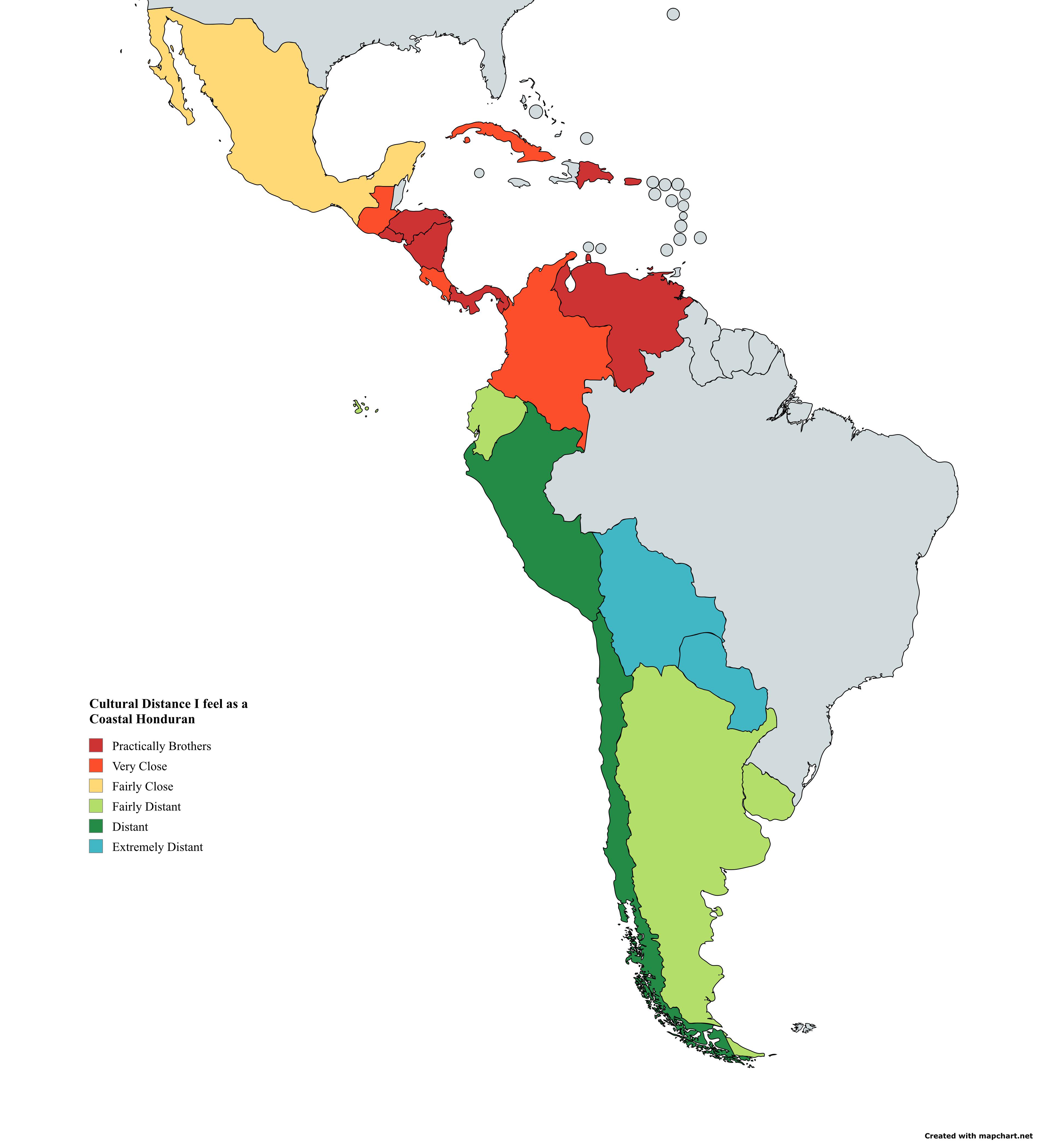
Cultural closeness i personally feel to hispano american countries as a honduran from the caribbean coast (Map)

Post image
139 Upvotes

THIS IS MY PERSONAL OPINION

Edit: i forgot to color my country honduras into something else.


r/MapPorn • • 12h ago

Countries you cross most on the fewest-borders route between two countries (like in Travle) [OC]

Post image
17 Upvotes

r/MapPorn • • 14h ago

Helmand Province (Afghanistan): When poppy cultivators went from a majority to a socio-economic empoverished and discriminated by their government minority [repost]

Post image
19 Upvotes

r/MapPorn • • 1d ago

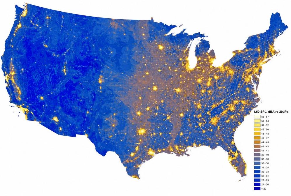
The loudest and quietest places in the US, according to the National Park Service

Post image
1.4k Upvotes

r/MapPorn • • 10h ago

Proto-Turkic Contacts with Other Languages

Post image
9 Upvotes
  • P-Ir. (BC. 1900-1000): Proto-Iranian
  • P-OU (BC. 600-0): Proto-Ob-Ugric
  • P-Yen (BC. 1000-100): Proto-Yeniseian
  • P-Sam (BC. 1000-300): Proto-Samoyedic
  • PIE(?): Proto-Indo-European
  • Toch B (?): Tocharian B
  • Pre-P-Mon (?): Pre-Proto-Mongolic
  • LOC (BC. 800-200): Late Old Chinese

r/MapPorn • • 1d ago

1962 Fall of Diefanbaker election

Post image
164 Upvotes

The 1962 election saw the Progressive Conservative government of John Diefanbaker reduced from the largest majority government in Canadian history to a weak minority government which would fall not even a year later. If you have any questions feel free to ask, I would be more than happy to explain.


r/MapPorn • • 10h ago

Since when has your country (public) suspension railways?

Post image
7 Upvotes

r/MapPorn • • 1d ago

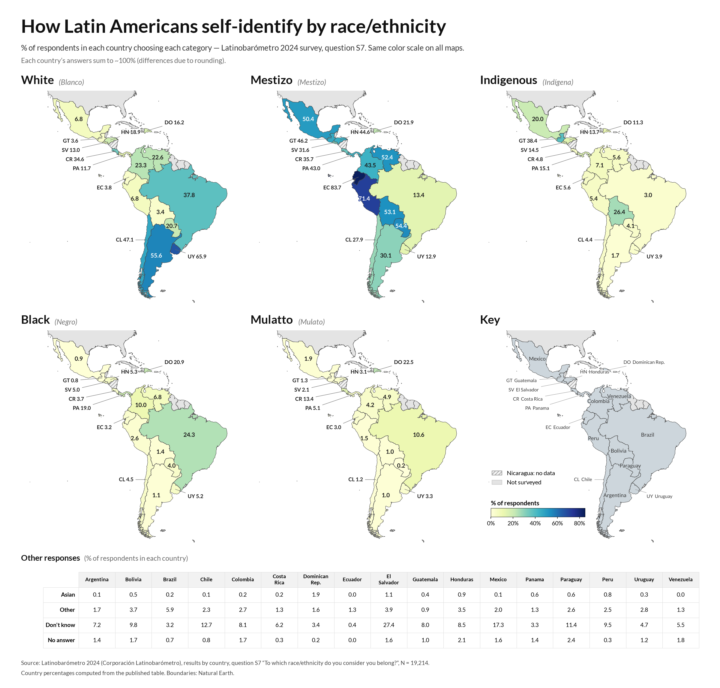
How Latin Americans self-identify by race/ethnicity, by country (Latinobarómetro 2024 survey) [OC]

Post image
468 Upvotes

Source: Latinobarómetro 2024, a public opinion survey run by Corporación Latinobarómetro across 17 Latin American countries (N = 19,214). Question S7: "¿A qué raza/etnia se considera perteneciente Ud.?" ("To which race/ethnicity do you consider you belong?"). Answer options: Asian, Black, Indigenous, Mestizo, Mulatto, White, Other, Don't know, No answer. Data from the published report Latinobarómetro 2024 – Resultados por país, p. 148.

Methodology: The published table shows each category's respondents distributed across countries (e.g., 17.5% of everyone who answered "White" was in Uruguay), not each country's own breakdown. I converted it using the sample sizes in the same table: respondents in a category = column % × category total, and country sample = country % × 19,214. Then I divided the two. Example for Uruguay: 17.5% × 4,485 ≈ 785 White respondents, out of 6.2% × 19,214 ≈ 1,191 Uruguayans surveyed, which gives ≈ 65.9%. Because the source percentages are rounded, each country's total comes out within about 1 point of 100%.

Notes: This is self-identification, not census or genetic data, and the answer categories mean different things in different countries. Nicaragua has no data in the 2024 table. Country samples are about 1,000–1,200 people each, so small differences shouldn't be over-read. Boundaries come from Natural Earth. Made with Python (geopandas/matplotlib).

EDIT: A few clarifications, since some of the same points keep coming up

  • This isn't an American survey. Latinobarómetro is a Chilean nonprofit based in Santiago. It has polled across Latin America every year since 1995. The categories were written in Spanish (and translated into Portuguese for Brazil) by Latin Americans, for Latin Americans. Not everything is about the US or how Americans see race.
  • What the map shows. As the title says, it shows how people self-identified when they were all shown the same list. It doesn't measure ancestry, genetics, or what a country "really" is.
  • What self-identification means. Each respondent picked the label they feel fits them. If "white" means pale skin to some people and "indio" means a skin tone to others, that's part of what the data captures. That variation is the interesting part, not a flaw.
  • Why "my country is mostly X" isn't relevant. Your view of your country's makeup, its census, or its DNA isn't what was asked. The question is how people describe themselves, and these are their answers.
  • Why one list for everyone. Standard categories make countries comparable. Local terms like "pardo" or "moreno" would make each country's results more precise, but you couldn't compare them with the rest of the region.
  • Check the sources. The report, page number, and methodology are linked in the post for a reason. Please read them and fact-check before commenting.

Thanks to everyone for the discussion, including the people who disagree.


r/MapPorn • • 20h ago

Europe 1799-1815 (vintage school map in Russian)

Post image
51 Upvotes

r/MapPorn • • 16h ago

Population in 100km radius

Post image
22 Upvotes

r/MapPorn • • 7m ago

World Press Freedom 2026

Post image
• Upvotes

r/MapPorn • • 20h ago

Greece in the "depths" of the Balkans. the 1913 Greek march to Sofia.

Post image
42 Upvotes

r/MapPorn • • 9h ago

[OC][Procreate] Cardiff City Line, Cardiff, Wales- Drawing Every Rail Line in Britain no.33

Post image
5 Upvotes

Sadly a lot of the Cardiff and Valleys Lines are dull, like this one. Central station is doing all the heavy lifting here visually, but it would look too sparse if I Didnt draw the other stations.


r/MapPorn • • 1d ago

World War 2 in Countryballs

Enable HLS to view with audio, or disable this notification

1.3k Upvotes

Made with my own software Mapping Creator.


r/MapPorn • • 19h ago

Results of the 2002 Portuguese legislative election by district.

Post image
29 Upvotes

Source

The centre-right PSD won 105 seats and 40% of the popular vote versus 96 seats and 37% of the popular vote for the centre-left PS.


r/MapPorn • • 20h ago

HistoryMaps presents: Polities

Enable HLS to view with audio, or disable this notification

37 Upvotes

https://history-maps.com/polities

Keyboard shortcuts on Map page:
< > = -/+ 1 year
shift < > -/+ 100 years
click the year = play/pause timeline


r/MapPorn • • 1d ago

Civil Conflict in Ethiopia now

Post image
768 Upvotes

Red: Federal Democratic Republic of Ethiopia

Green: Tigray People's Liberation Front (TPLF)

Gray: Fano (Amhara militia)

Blue: Oromo Liberation Army (OLA)

Pink: Afar National Unity Revolutionary Front (ANURF)


r/MapPorn • • 1d ago

KFC across South Asia

Post image
668 Upvotes

Source: Databandar


r/MapPorn • • 19h ago

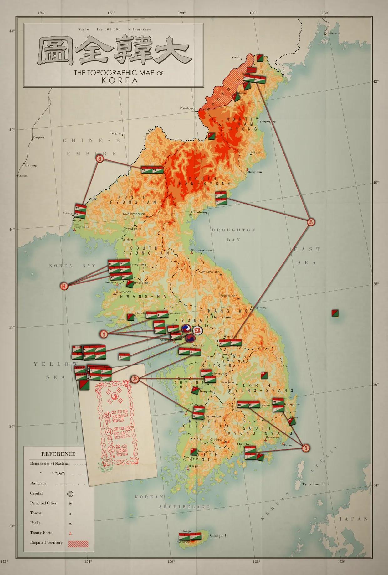
1903 Korean Empire Army Military Deployment Map Poster

Post image
20 Upvotes

r/MapPorn • • 4h ago

GeographyWorlds: Where half are under 16?

Post image
1 Upvotes