r/TropicalWeather • • 8d ago

Official discussion Moderation feedback and upcoming changes to the subreddit

94 Upvotes

Good afternoon!

I want to give you all a platform for sharing your feedback of the subreddit and how I have been doing as a moderator. I am far more interested in negative feedback. I appreciate the compliments, but I really want to know what annoys you about the subreddit (or me as a moderator personally) and what needs to be fixed going forward.

Here are some things that are already in the works or have already been implemented:

No more advisory junk

Posts for active disturbances and cyclones will no longer feature discussions, observational data, or advisory charts. I have been updating these manually by myself for years and it is clear that I am unable to update them in a timely enough manner for the information to even matter. Please use the links provided in each post to get the information you need form more authoritative sources.

  • Clarification: If I can ever get around to learning how to make this an automated process, these features may return to posts. If you are interested in becoming a moderator and can demonstrate that you know enough about the Reddit API and development tools to create an automated process for this, please reply to the stickied comment. I'd love to discuss this with you in the future.

No more basin filtering

Before the new version of Reddit became active, we were able to create a link flair filter which allowed users to filter the subreddit based on cyclone basin. You could click a link in the sidebar which would only show posts tagged with Atlantic, Pacific, Indian, etc. This functionality no longer works and therefore, the link flairs have been simplified and the filter buttons have been removed from the sidebar.

  • Clarification: These filters used a URL trick to hide posts which did not match the specified CSS class of the link flair. These filters only worked on the old version of the desktop website and never worked in the app or in third-party tools. Once the URL trick was depreciated, the filters no longer actually worked, so they were removed.

Looser posting requirements

I will be loosening up the "soft restricted" mode, allowing more posts to hit the front page of the subreddit without needing to be reviewed by a moderator first. There are only two active mods right now and sometimes posts sit in the queue for more than a day. Often, users will delete their posts before I have the chance to review them. If new posts violate the rules, please report them so that I can remove them.

  • Clarification: I do not intend to open the floodgates to all content. There are existing fallback filters which should catch rule-violating content and content from banned sources. I will be working to improve these filters to ensure that unwanted content does not reach the subreddit. I will also be working on an expanded approved users list so that content by trusted users does not require moderator approval.

No more live threads

Many people have been asking where the Live Threads have gone. For one, there are not enough moderators or volunteers to help maintain Live Threads. Second, Reddit does not officially support Live Threads anymore. It is a feature of the old version of the website which has not been regularly maintained in years.

Moderator applications

Once Hurricane Isaias makes landfall and dissipates, I will be opening up moderator applications. I really need to step away from the day-to-day operations of this subreddit and let it flourish on its own, but I will need help doing that. The new version of Reddit has a moderator application function. I will be reviewing that over the weekend and making it active sometime next week. I will post a new discussion for that purpose to the subreddit.

Update


Status of the Discord

Although I am one of the administrators of the TropicalWeather Discord server, the server is no longer officially affiliated with the subreddit.

Preserving the style of the subreddit

I also want to clarify that I do not have any personal beef with r/hurricane. Both r/hurricane and r/tropicalweather have completely different approaches to sharing this important information and I want to maintain that distinction. I will continue to resist calls to make our subreddit more like theirs and I will continue to discourage people from insisting that their subreddit needs to be more like hours.


r/TropicalWeather • • 1h ago

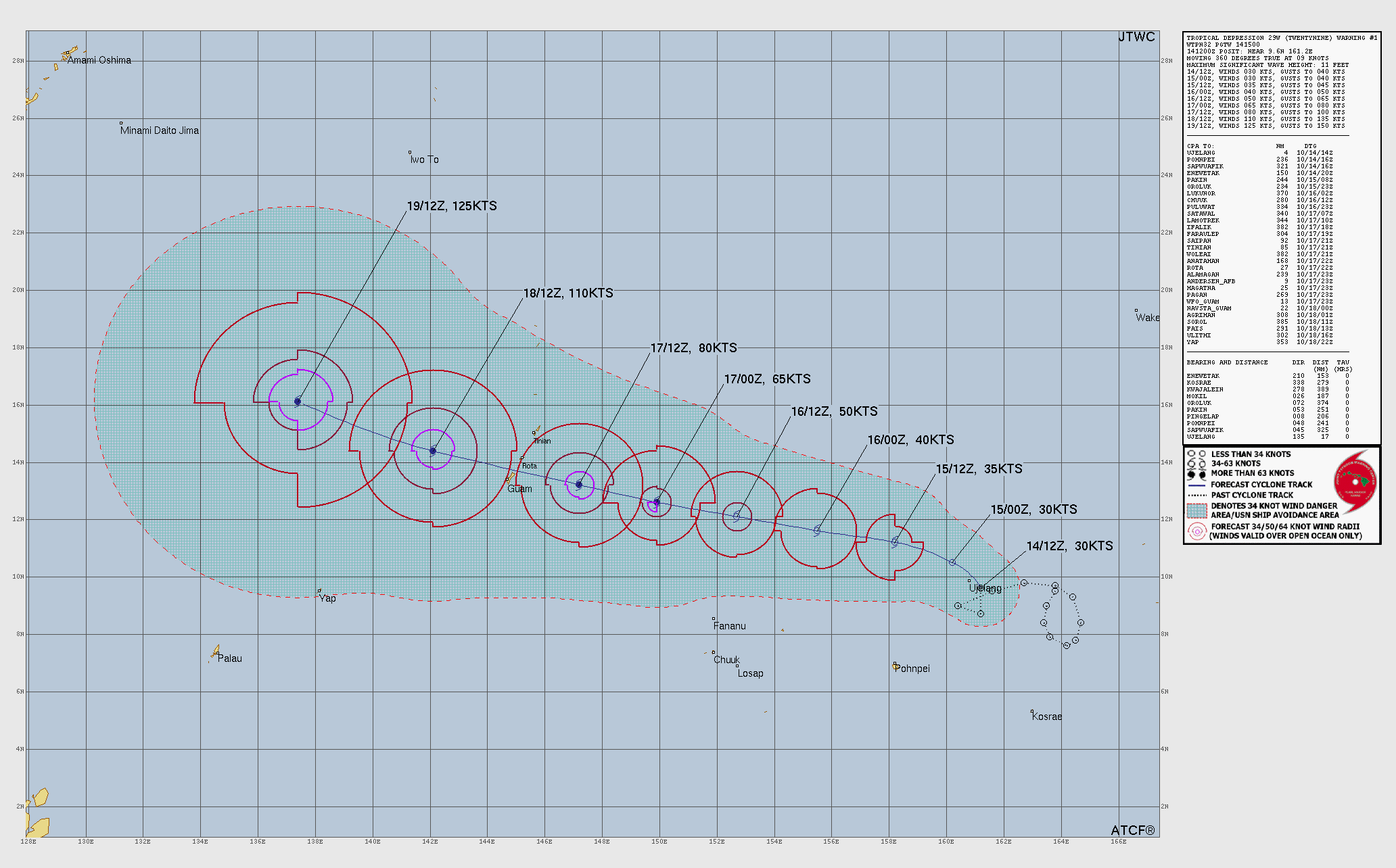
▲ Very Strong Typhoon (H4) | 130 knots (150 mph) | 934 mbar Champi (29W — Western Pacific) (Philippine Sea)

• Upvotes

Storm overview


This discussion is for Typhoon Champi (29W), which is active over the western Pacific Ocean.

Champi remains a powerful and well-organized cyclone as it passes to the south of Guam this morning. The storm is moving westward to west-northwestward under the steering influence of a deep-layered subtropical ridge positioned to the north. Although environmental conditions remain favorable and should support further development over the next couple of days, Champi may undergo fluctuations in intensity as it continues to undergo eyewall replacement cycles. The storm is expected to reach the equivalent strength of a Category 5 hurricane as it moves across the Philippine Sea to the west of the Northern Marianas Islands over the next day or so.

Model guidance suggests that the subtropical ridge will hold its position over the next several days, keeping Champi on a west-northwestward track for the next several days. Champi could be close to the eastern coast of Taiwan by the end of the forecast period on Friday morning.

Official information


Japan Meteorological Agency

Joint Typhoon Warning Center (United States)

National Weather Service (United States)

Radar imagery


Radar imagery is not currently available for this system.

Satellite imagery


Floater imagery

Visible imagery

Infrared imagery

Water vapor imagery

Multiple bandwidth imagery

Regional imagery

Visible imagery

Infrared imagery

Water vapor imagery

Analysis products


Observational history

Scatterometer data

Sea-surface temperatures

Forecast models


Storm-centered guidance

Multi-model guidance

Single-model click-through guidance

Tropical Tidbits

CyclonicWx

Ensemble model guidance

PolarWx

Regional guidance

Global models

TropicalTidbits

CyclonicWx

Weather Nerds

Ensemble models

Tropical Tidbits

CyclonicWx

Weather Nerds

Machine learning models (AI)

Tropical Tidbits

CyclonicWx

Weather Nerds

Other types of model guidance


r/TropicalWeather • • 4h ago

▲ Forecast Outlook | National Hurricane Center | 20% potential The NHC is monitoring an area of potential development off the eastern coast of the United States

16 Upvotes

Disturbance overview


This discussion is for an area of potential tropical cyclone development off the coast of the mid-Atlantic region of the United States. A disturbance has not yet formed and has not yet been designated as an investigation (invest) area by the National Hurricane Center.

Surface analysis indicates that the tail end of a cold front associated with an area of low pressure positioned over Newfoundland and Labrador is currently draped along the eastern coast of the United States. Model guidance suggests that a strong area of low pressure is likely to develop along this frontal boundary within the next 24 to 36 hours. The developing storm is expected to be non-tropical at first, but could gain some subtropical characteristics over the next few days as it moves slowly and erratically northward.

Although this system is likely to remain offshore for the next several days, it will likely be broad enough to bring strong winds, coastal flooding, and dangerous surf conditions to portions of the eastern coast of the United States through the upcoming week.

Official information


National Hurricane Center

Text products

Graphical products

Radar imagery


Radar imagery is not currently available for this system.

Satellite imagery


Floater imagery

Visible imagery

Disturbance-centered satellite imagery is not yet available for this system.

Regional imagery

Visible imagery

Infrared imagery

Water vapor imagery

Analysis products


Observational history

Observational history is not yet available for this system.

Scatterometer data

Sea-surface temperatures

Forecast models


Disturbance-centered guidance

Multi-model guidance

Ensemble model guidance

PolarWx

Regional guidance

Global models

TropicalTidbits

CyclonicWx

Weather Nerds

Ensemble models

Tropical Tidbits

CyclonicWx

Weather Nerds

Machine learning models (AI)

Tropical Tidbits

CyclonicWx

Weather Nerds

Other types of model guidance


r/TropicalWeather • • 3h ago

Radar Imagery Refectivity showing Typhoon Champi's intense inner core missing just to the south of Guam's southern coastline.

9 Upvotes

Guam is incredibly lucky here as it appears Champi is further intensifying as the inner core passes by just to the south. Notice the intense mesovorticies rotating around the inner edge of the eyewall. In the last frame, you will see a very well-defined meso with bright purple reflectivity in the NW quadrant of the eye. Champi is most likely about to be a super typhoon, if not already. Again, Guam is getting incredibly lucky here despite the impacts they are experiencing.

Edit: Title should spell "Reflectivity."


r/TropicalWeather • • 6h ago

Question Could someone please explain this anomaly?

10 Upvotes

I see this funnel of very strong winds blowing south between the Caribbean and Pacific whenever there is a hurricane, or even stormy weather in the Pacific.


r/TropicalWeather • • 6m ago

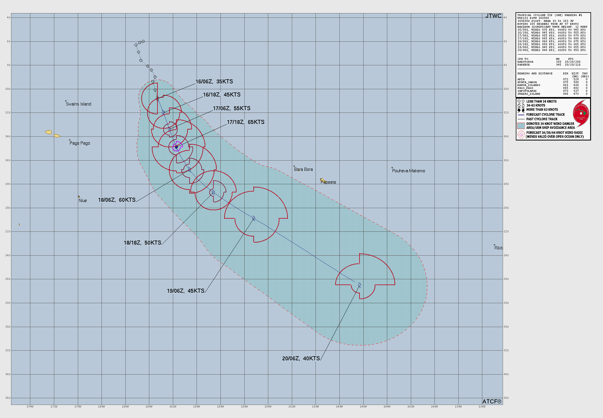
▲ Cyclone (Category 2) | 65 knots (75 mph) | 985 mbar Wati (01P — Southern Pacific) (North of the Cook Islands)

• Upvotes

Storm overview


This discussion is for Cyclone Wati (01P), which is active over the southern Pacific.

Satellite imagery analysis indicates that Wati has reached hurricane-equivalent strength. The storm, which is situated several hundred kilometers east of Samoa, is moving slowly south-southeastward along the western periphery of a subtropical ridge positioned to the east. Over the next few days, Wati will accelerate as it turns increasingly southeastward. Environmental conditions will remain favorable for the next 12 to 24 hours, allowing for some additional intensification. However, by early Sunday morning, the storm will begin to weaken as it moves over progressively cooler waters and encounters stronger vertical wind shear and drier air. This system may bring periods of heavy rain to portions of the Cook Islands early next week.

Information sources


Fiji Meteorological Service

Joint Typhoon Warning Center

Radar imagery


Radar imagery is not currently available for this system.

Satellite imagery


Floater imagery

Visible imagery

Infrared imagery

Water vapor imagery

Multiple bandwidth imagery

Regional imagery

NOTE: Neither Tropical Tidbits nor CyclonicWx have zoomed-in regional views of the southern Pacific Ocean.

Visible imagery

Infrared imagery

Water vapor imagery

Analysis products


Observational history

Scatterometer data

Sea-surface temperatures

Forecast models


Disturbance-centered guidance

Multi-model guidance

Single-model click-through guidance

Tropical Tidbits

CyclonicWx

Ensemble model guidance

PolarWx

Regional guidance

Global models

TropicalTidbits

CyclonicWx

Weather Nerds

Ensemble models

Tropical Tidbits

CyclonicWx

Weather Nerds

Machine learning models (AI)

Tropical Tidbits

CyclonicWx

Weather Nerds

Other types of model guidance


r/TropicalWeather • • 4h ago

▲ Forecast Outlook | National Hurricane Center | 70% potential The NHC is monitoring an area of potential development off the coast of southwestern Mexico

2 Upvotes

Disturbance overview


This discussion is for an area of potential tropical cyclone development off the coast of southern and southwestern Mexico. A disturbance has not yet formed and has not yet been designated as an investigation (invest) area by the National Hurricane Center.

Model guidance suggests that an area of low pressure will form several hundred kilometers off the coast of southern Mexico early next week. The disturbance is likely to move west-northwestward under the steering influence of a subtropical ridge positioned over Mexico and is likely to steadily develop as it experiences favorable environmental conditions. A tropical depression or storm is increasingly likely to develop by the middle of the upcoming week.

Breaking from previous storms, such as Hurricanes Simon and Trudy, model guidance suggests that this system will continue out to sea through the end of the upcoming week.

Official information


National Hurricane Center

Text products

Graphical products

Radar imagery


Radar imagery is not currently available for this system.

Satellite imagery


Floater imagery

Disturbance-centered satellite imagery is not yet available for this system.

Regional imagery

Visible imagery

Infrared imagery

Water vapor imagery

Analysis products


Observational history

Observational history is not yet available for this system.

Scatterometer data

Sea-surface temperatures

Forecast models


Disturbance-centered guidance

Individual models

PolarWx

Ensemble model guidance

PolarWx

Regional guidance

Global models

TropicalTidbits

CyclonicWx

Weather Nerds

Ensemble models

Tropical Tidbits

CyclonicWx

Weather Nerds

Machine learning models (AI)

Tropical Tidbits

CyclonicWx

Weather Nerds

Other types of model guidance


r/TropicalWeather • • 17h ago

Seasonal Forecast | Earth Sciences New Zealand Southwest Pacific Tropical Cyclone Outlook - October 2026

Thumbnail
niwa.co.nz
1 Upvotes

r/TropicalWeather • • 2d ago

Image of the Day | NASA Science Hurricane Simon Lurks Off the Mexican Coast - NASA Science

Thumbnail
science.nasa.gov
14 Upvotes

r/TropicalWeather • • 2d ago

Image of the Day | NASA MODIS Hurricane Simon Whips Southwestern Mexico - October 12, 2026

Thumbnail modis.gsfc.nasa.gov
8 Upvotes

r/TropicalWeather • • 3d ago

▼ Hurricane (Category 1) | 75 knots (85 mph) | 982 mbar Trudy (21E — Eastern Pacific) (South of Mexico)

8 Upvotes

Storm overview


This discussion is for Tropical Storm Trudy (21E), which is active over the eastern Pacific.

A tropical depression which formed several hundred kilometers off the coast of southern Mexico continues to become better organized and estimates derived from satellite imagery analysis reveal that it is now producing tropical storm-force winds. The storm, which has been assigned the name Trudy by the National Hurricane Center (NHC), is moving northwestward under the steering influence of a mid-level ridge which persists over the Gulf of Mexico. Environmental conditions remain favorable and should allow Trudy to continue to steadily develop over the next couple of days.

The mid-level steering ridge is expected to weaken and retreat eastward over the next couple of days, leaving behind a very weak steering environment and causing Trudy to slow down. The storm will likely turn slightly northward as its movement becomes more heavily influenced by Hurricane Simon, which will still be active off the coast of western Mexico. A cold front may swoop down across Texas and Mexico later in the week and could pull Trudy closer to the coast toward the end of the week. There remains a high degree of uncertainty regarding Trudy’s track during the latter half of the week.

Official information


National Hurricane Center

Text products

Graphical products

Radar imagery


Radar imagery is not currently available for this system.

Satellite imagery


Floater imagery

Visible imagery

Infrared imagery

Water vapor imagery

Multiple bandwidth imagery

Regional imagery

Visible imagery

Infrared imagery

Water vapor imagery

Analysis products


Observational history

Scatterometer data

Sea-surface temperatures

Forecast models


Disturbance-centered guidance

Multi-model guidance

Single-model click-through guidance

Tropical Tidbits

CyclonicWx

Ensemble model guidance

PolarWx

Regional guidance

Global models

TropicalTidbits

CyclonicWx

Weather Nerds

Ensemble models

Tropical Tidbits

CyclonicWx

Weather Nerds

Machine learning models (AI)

Tropical Tidbits

CyclonicWx

Weather Nerds

Other types of model guidance


r/TropicalWeather • • 3d ago

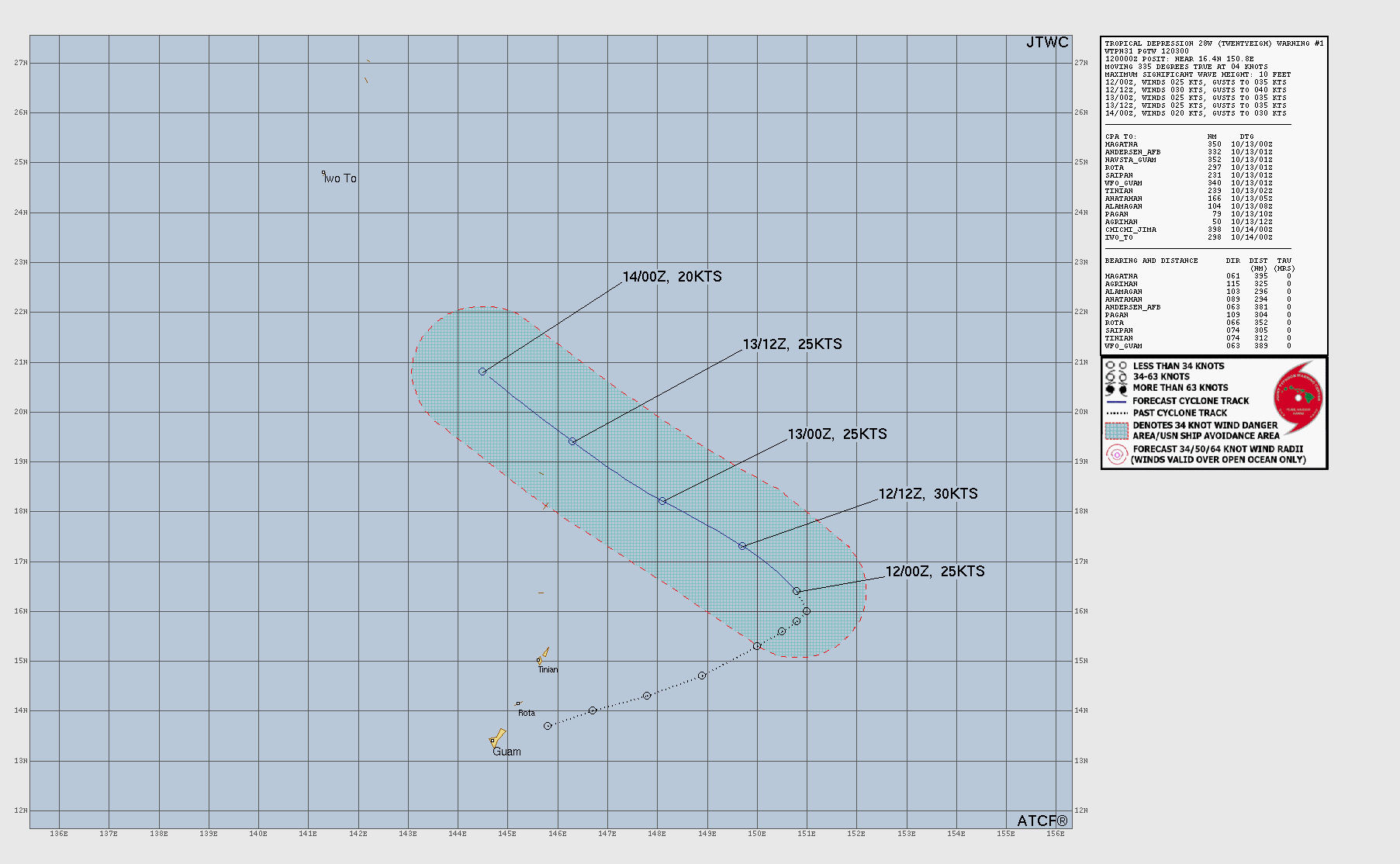
Dissipated 28W (Western Pacific) (South of Japan)

3 Upvotes

Storm overview


This discussion is for Tropical Depression Twenty-eight (28W), which is active over the western Pacific.

A tropical depression remains active a few hundred kilometers southeast of Iōto in Japan’s Ogasawara Islands. The depression has not undergone any significant changes in strength or structure over the past several hours; its low-level center remains exposed and only a few isolated bursts of deep convection continue to flare up to the southwest. This system continues to move toward the west-northwest under the steering influence of a deep-layered subtropical ridge positioned to the northeast. Upper-level convergence associated with a trough positioned directly above the depression is suppressing any potential for outflow development, preventing the depression from developing in an otherwise highly favorable environment.

This system is likely to stop producing persistent thunderstorm activity and will degenerate into a remnant low as it passes well to the south of Iōto by the end of the week.

Official information


Japan Meteorological Agency

Though the JMA does classify this system as a tropical depression on its surface analysis and prognosis charts, it has not initiated issuing tropical cyclone warnings for it.

Joint Typhoon Warning Center (United States)

Radar imagery


Radar imagery is not currently available for this system.

Satellite imagery


Floater imagery

Visible imagery

Infrared imagery

Water vapor imagery

Multiple bandwidth imagery

Regional imagery

Visible imagery

Infrared imagery

Water vapor imagery

Analysis products


Observational history

Scatterometer data

Sea-surface temperatures

Forecast models


Storm-centered guidance

Multi-model guidance

Single-model click-through guidance

Tropical Tidbits

CyclonicWx

Ensemble model guidance

PolarWx

Regional guidance

Global models

TropicalTidbits

CyclonicWx

Weather Nerds

Ensemble models

Tropical Tidbits

CyclonicWx

Weather Nerds

Machine learning models (AI)

Tropical Tidbits

CyclonicWx

Weather Nerds

Other types of model guidance


r/TropicalWeather • • 3d ago

Discussion My wishes for the meteorological community

2 Upvotes

This subreddit serves multiple purposes. It's like a newspaper for those interested in the academic aspects of tropical cyclones. It's an educational community communication hub for those who are potentially in harm's way.

The greatest potential harm to humans appears not be associated with peak wind speed or lowest central air pressure. The greatest threat seems to be related to the volume of water which be transferred into their land territory. Rainfall and surge are storm specific water invasions.

The Saffir-Simpson index is misleading to the public because it offers a metric which appears to represent hurricane strength as having reached a peak.

The community would benefit from some innovation and better metrics which appropriately and unequivocally inform the world that these storms are becoming more dangerous. Not only as a result of storm specific surge and rainfall, but also due to chronic rise in sea levels.

How does such innovation arise? It begins with people saying that they represent a market for that information. Is there anyone else who would like to be informed of the increasing volumes of water being transferred inland as a result of these storms?


r/TropicalWeather • • 4d ago

Discussion Trying to learn ..... why did Simon deviate so far outside the cone?

34 Upvotes

At the 3PM CST update on October 10th, the NHC update indicated that Simon would move laterally from 104.8W to 105.2W over the ensuing 48 hours.

INIT  10/2100Z 17.6N 104.8W  130 KT 150 MPH
 12H  11/0600Z 18.3N 104.9W  130 KT 150 MPH
 24H  11/1800Z 19.4N 105.1W  110 KT 125 MPH
 36H  12/0600Z 20.8N 105.2W   70 KT  80 MPH...INLAND
 48H  12/1800Z 21.9N 105.2W   45 KT  50 MPH...INLAND

At the 3PM CST update on Oct 12th, Simon was actually located at 106.8W

INIT  12/2100Z 20.2N 106.8W   85 KT 100 MPH

Instead of a 0.4 degree shift in longitude, Simon moved 2.0 degrees.

The latitude miss was 1.7 degrees (21.9N forecast vs 20.2N actual)

These kinds of deviations from forecast are quite unusual. Something took place which the forecasters didn't anticipate.

What happened that forecasters didn't anticipate? What do we learn from this?


r/TropicalWeather • • 5d ago

Image of the Day | NASA MODIS Hurricane Isaias - October 9, 2026

Thumbnail modis.gsfc.nasa.gov
4 Upvotes

r/TropicalWeather • • 6d ago

D The NHC is monitoring an area of potential development over the tropical eastern Atlantic

47 Upvotes

Disturbance overview


  • This discussion was for a disturbance situated near Cabo Verde in the tropical eastern Atlantic.
  • This system has dissipated and no longer shows any potential for development.
  • There will be no further updates to this post.

Official information


National Hurricane Center

Text products

Graphical products

Radar imagery


Radar imagery is not currently available for this system.

Satellite imagery


Floater imagery

Disturbance-centered satellite imagery is not currently available for this system.

Regional imagery

Visible imagery

Infrared imagery

Water vapor imagery

Analysis products


Observational history

Observational history is not currently available for this system.

Scatterometer data

Sea-surface temperatures

Forecast models


Disturbance-centered guidance

Disturbance-centered model guidance is not currently available for this system.

Regional guidance

Global models

TropicalTidbits

CyclonicWx

Weather Nerds

Ensemble models

Tropical Tidbits

CyclonicWx

Weather Nerds

Machine learning models (AI)

Tropical Tidbits

CyclonicWx

Weather Nerds

Other types of model guidance


r/TropicalWeather • • 6d ago

Satellite Imagery GOES Satellite: Motion-derived winds- Remnants of Hurricane Isaias, Tropical Storm Rachel and Hurricane Simon 10-10-26

Thumbnail
youtu.be
18 Upvotes

r/TropicalWeather • • 7d ago

Satellite Imagery Typhoon Koguma (2026) has a Near-Perfect Overall Shape!

Post image
173 Upvotes

This Satellite image of Typhoon Koguma was taken at October 10th 08:50PM (22° 41'N, 149° 48' E). With Wind speeds of 130 mph (Category 4 Typhoon) and a Barometric Pressure of 945 millibars.


r/TropicalWeather • • 7d ago

Seasonal Discussion · EPAC ACE record broken Counting down to the EPAC ACE Record .....

17 Upvotes

The EPAC ACE record of 319.26 from 2018 could fall in the next couple of days.

The most recent update has 2026 EPAC ACE at 307.9.

Rachel has maybe 1.5 ACE left in the tank leaving us 10 shy and if Simon holds to the forecast or exceeds it, then it seems that's enough to get 2026 over the top.

The strong El Nino stereotype is emerging in the statistics.


r/TropicalWeather • • 8d ago

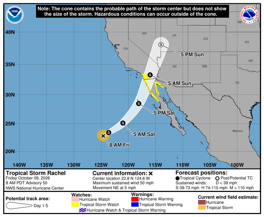
Forecast Advisory second ever tropical storm watch issued for california

Post image
196 Upvotes

r/TropicalWeather • • 8d ago

Video | YouTube | Dr. Levi Cowan (Tropical Tidbits) (Outdated) Tropical Tidbit for Friday, 9 October — Category 3 Hurricane Isaias Nearing Landfall

Thumbnail
youtu.be
102 Upvotes

r/TropicalWeather • • 8d ago

Satellite Imagery Hurricane Simon developing a pinhole eye and very cold cloud tops around said eye. It's expected to intensify and impact the Mexican states of Jalisco and Colima.

Thumbnail gallery
19 Upvotes

r/TropicalWeather • • 8d ago

Video | YouTube | National Hurricane Center (Outdated) NHC Morning Update for Hurricane Isaias — Friday, 9 October 2026

Thumbnail
youtube.com
27 Upvotes

r/TropicalWeather • • 8d ago

Question Has NOLO set a record for greatest longitude traveled ?

39 Upvotes

NOLO made its debut at 117W longitude and has now passed 150E longitude. That's more than 25% of the Earth's longitudinal span. It's possible that this is a global tropical cyclone record for longitude traversed.


r/TropicalWeather • • 9d ago

Discussion Isaias, model by model: physics vs. statistical vs. AI intensity forecasts from NHC’s public data, plus what has already verified.

35 Upvotes

Hi folks, I’m a computational engineer with a background in fluid dynamics. Isaias is forecast to make landfall near Mobile Bay, where my parents live. My dad is recovering from open-heart surgery, so I’m driving down to do the heavy lifting and chainsaw work he shouldn’t be doing.

Before I left, I wanted to understand why the intensity guidance disagrees. Physics-based, statistical and AI models are all forecasting this storm, and it’s an interesting test of how they compare. So I built a page from NHC’s public model and best-track data:

https://lukemcculloch.github.io/static_hurricane_info_site/

What it shows, as of the 12Z Thu cycle:

Every number is reproducible from scripts in the repo (bash/awk on NOAA’s files), and the methods page lists the caveats. The page updates each cycle and archives the earlier versions, so the pre-landfall versions stay on record. After landfall I’ll score each aid against the best track.

I am in a hurry to get on the road, so I generated this, directing Claude Opeus 5.5 medium while I was packing up. I also used it to help me remember what supplies to bring.

emphasis: (Built with help from Claude for the coding and data processing.)
(I hope you guys don't tear me to ribbons, but one must let the chips fall where they may, heh)

This is not a forecast. Use NHC and your local NWS office for decisions. Corrections are welcome here or as GitHub issues.

Stay safe, everyone on the Gulf Coast.

Notes: this site will update when I can stop in to get online with the latest data, if I feel I have time.

my github is here: https://github.com/LukeMcCulloch/static_hurricane_info_site