r/TropicalWeather • • 5h ago

▲ Forecast Outlook | National Hurricane Center | 20% potential The NHC is monitoring an area of potential development off the eastern coast of the United States

21 Upvotes

Disturbance overview


This discussion is for an area of potential tropical cyclone development off the coast of the mid-Atlantic region of the United States. A disturbance has not yet formed and has not yet been designated as an investigation (invest) area by the National Hurricane Center.

Surface analysis indicates that the tail end of a cold front associated with an area of low pressure positioned over Newfoundland and Labrador is currently draped along the eastern coast of the United States. Model guidance suggests that a strong area of low pressure is likely to develop along this frontal boundary within the next 24 to 36 hours. The developing storm is expected to be non-tropical at first, but could gain some subtropical characteristics over the next few days as it moves slowly and erratically northward.

Although this system is likely to remain offshore for the next several days, it will likely be broad enough to bring strong winds, coastal flooding, and dangerous surf conditions to portions of the eastern coast of the United States through the upcoming week.

Official information


National Hurricane Center

Text products

Graphical products

Radar imagery


Radar imagery is not currently available for this system.

Satellite imagery


Floater imagery

Visible imagery

Disturbance-centered satellite imagery is not yet available for this system.

Regional imagery

Visible imagery

Infrared imagery

Water vapor imagery

Analysis products


Observational history

Observational history is not yet available for this system.

Scatterometer data

Sea-surface temperatures

Forecast models


Disturbance-centered guidance

Multi-model guidance

Ensemble model guidance

PolarWx

Regional guidance

Global models

TropicalTidbits

CyclonicWx

Weather Nerds

Ensemble models

Tropical Tidbits

CyclonicWx

Weather Nerds

Machine learning models (AI)

Tropical Tidbits

CyclonicWx

Weather Nerds

Other types of model guidance


r/TropicalWeather • • 7h ago

Question Could someone please explain this anomaly?

9 Upvotes

I see this funnel of very strong winds blowing south between the Caribbean and Pacific whenever there is a hurricane, or even stormy weather in the Pacific.


r/TropicalWeather • • 2h ago

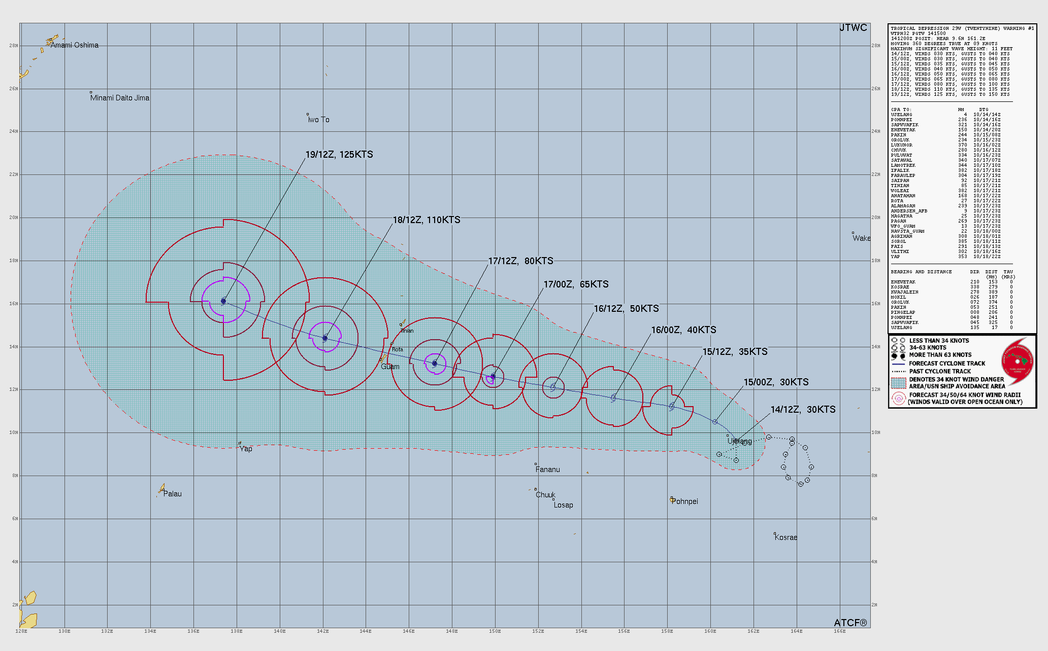
▲ Very Strong Typhoon (H4) | 130 knots (150 mph) | 934 mbar Champi (29W — Western Pacific) (Philippine Sea)

2 Upvotes

Storm overview


This discussion is for Typhoon Champi (29W), which is active over the western Pacific Ocean.

Champi remains a powerful and well-organized cyclone as it passes to the south of Guam this morning. The storm is moving westward to west-northwestward under the steering influence of a deep-layered subtropical ridge positioned to the north. Although environmental conditions remain favorable and should support further development over the next couple of days, Champi may undergo fluctuations in intensity as it continues to undergo eyewall replacement cycles. The storm is expected to reach the equivalent strength of a Category 5 hurricane as it moves across the Philippine Sea to the west of the Northern Marianas Islands over the next day or so.

Model guidance suggests that the subtropical ridge will hold its position over the next several days, keeping Champi on a west-northwestward track for the next several days. Champi could be close to the eastern coast of Taiwan by the end of the forecast period on Friday morning.

Official information


Japan Meteorological Agency

Joint Typhoon Warning Center (United States)

National Weather Service (United States)

Radar imagery


Radar imagery is not currently available for this system.

Satellite imagery


Floater imagery

Visible imagery

Infrared imagery

Water vapor imagery

Multiple bandwidth imagery

Regional imagery

Visible imagery

Infrared imagery

Water vapor imagery

Analysis products


Observational history

Scatterometer data

Sea-surface temperatures

Forecast models


Storm-centered guidance

Multi-model guidance

Single-model click-through guidance

Tropical Tidbits

CyclonicWx

Ensemble model guidance

PolarWx

Regional guidance

Global models

TropicalTidbits

CyclonicWx

Weather Nerds

Ensemble models

Tropical Tidbits

CyclonicWx

Weather Nerds

Machine learning models (AI)

Tropical Tidbits

CyclonicWx

Weather Nerds

Other types of model guidance


r/TropicalWeather • • 4h ago

Radar Imagery Refectivity showing Typhoon Champi's intense inner core missing just to the south of Guam's southern coastline.

12 Upvotes

Guam is incredibly lucky here as it appears Champi is further intensifying as the inner core passes by just to the south. Notice the intense mesovorticies rotating around the inner edge of the eyewall. In the last frame, you will see a very well-defined meso with bright purple reflectivity in the NW quadrant of the eye. Champi is most likely about to be a super typhoon, if not already. Again, Guam is getting incredibly lucky here despite the impacts they are experiencing.

Edit: Title should spell "Reflectivity."


r/TropicalWeather • • 5h ago

▲ Forecast Outlook | National Hurricane Center | 70% potential The NHC is monitoring an area of potential development off the coast of southwestern Mexico

2 Upvotes

Disturbance overview


This discussion is for an area of potential tropical cyclone development off the coast of southern and southwestern Mexico. A disturbance has not yet formed and has not yet been designated as an investigation (invest) area by the National Hurricane Center.

Model guidance suggests that an area of low pressure will form several hundred kilometers off the coast of southern Mexico early next week. The disturbance is likely to move west-northwestward under the steering influence of a subtropical ridge positioned over Mexico and is likely to steadily develop as it experiences favorable environmental conditions. A tropical depression or storm is increasingly likely to develop by the middle of the upcoming week.

Breaking from previous storms, such as Hurricanes Simon and Trudy, model guidance suggests that this system will continue out to sea through the end of the upcoming week.

Official information


National Hurricane Center

Text products

Graphical products

Radar imagery


Radar imagery is not currently available for this system.

Satellite imagery


Floater imagery

Disturbance-centered satellite imagery is not yet available for this system.

Regional imagery

Visible imagery

Infrared imagery

Water vapor imagery

Analysis products


Observational history

Observational history is not yet available for this system.

Scatterometer data

Sea-surface temperatures

Forecast models


Disturbance-centered guidance

Individual models

PolarWx

Ensemble model guidance

PolarWx

Regional guidance

Global models

TropicalTidbits

CyclonicWx

Weather Nerds

Ensemble models

Tropical Tidbits

CyclonicWx

Weather Nerds

Machine learning models (AI)

Tropical Tidbits

CyclonicWx

Weather Nerds

Other types of model guidance


r/TropicalWeather • • 18h ago

Seasonal Forecast | Earth Sciences New Zealand Southwest Pacific Tropical Cyclone Outlook - October 2026

Thumbnail
niwa.co.nz
1 Upvotes