r/geography • u/bittlemv124 • 2h ago
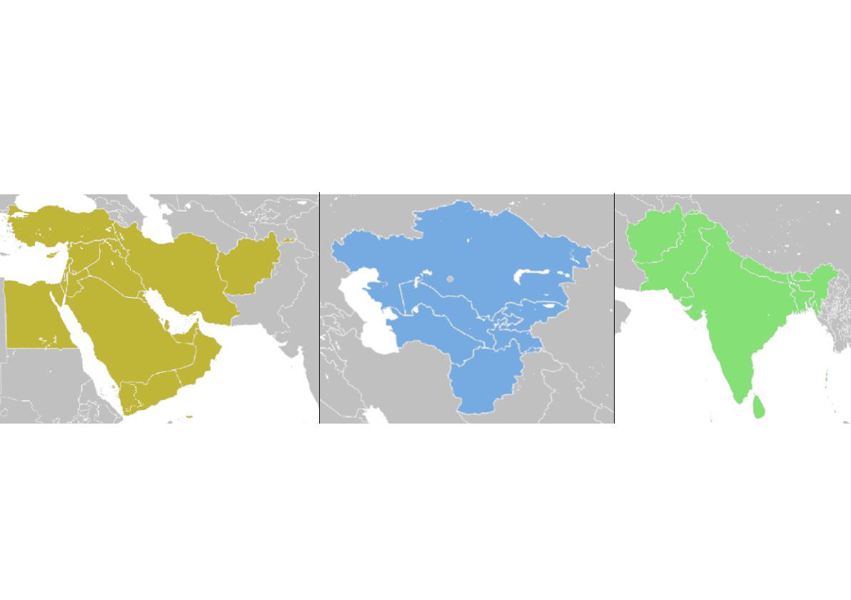
Question What is going on in the box? The borders seem to be overlapping in a unique pattern.

243
Upvotes
r/geography • u/abu_doubleu • Sep 12 '26
r/geography • u/bittlemv124 • 2h ago
r/geography • u/TrixoftheTrade • 10h ago
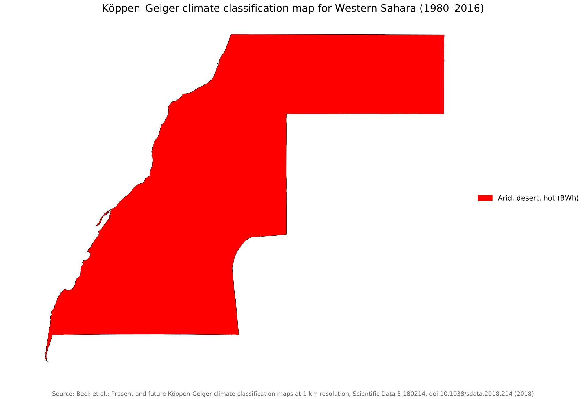
The entire country of Western Sahara is hot desert, completely without exception (down to 1 km resolution).
Its location (20 - 28° N) puts it squarely in the desert belt, and it’s western-facing shoreline has an off-shore breeze, pushing dry air out rather than moist air on, and without any mountains (highest point is only 2,300 ft), makes the country uniformly hot desert.
Are there any other countries (excluding
microstates) that are completely 1 climate type?
r/geography • u/Forsaken-Addition718 • 3h ago
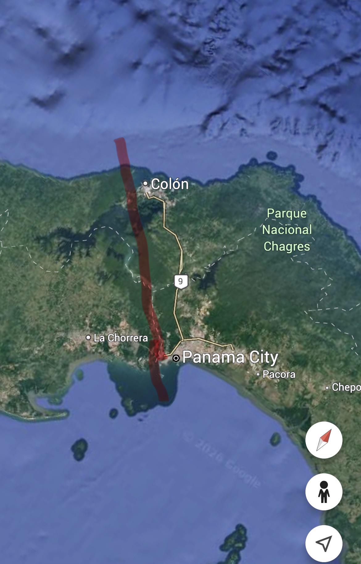
Direction of Canal is North-west to South-East actually
r/geography • u/Forsaken-Addition718 • 3h ago
Border only of 0.8 miles making it one of the smallest international border, also one of the most recent transnational border
r/geography • u/DesiccantPack • 10h ago
r/geography • u/1hourphoto_ • 13h ago
“Florida is FLAT “
actually…
r/geography • u/Jazzlike_League_480 • 2h ago
r/geography • u/2001_Arabian_Nights • 6h ago
The “Sassi” in Matera, Italy are cave dwellings that have been occupied for roughly 9,000 years in a hilltop town in South Italy. Most of the original inhabitants were forcefully relocated in the 1950s due to their extreme poverty and their “unsafe living conditions”, but some stubborn holdouts remained.
Over the millennia the cave dwellings and their exterior facades were continuously improved on, but many of the interiors have barely changed. In 1993 the Sassi were declared a World Heritage Site and the local government began encouraging conservation and development in the area. Today hotels use some of the ancient cave dwellings for rooms.
r/geography • u/Jezzaq94 • 23h ago
r/geography • u/One-Seat-4600 • 1d ago
r/geography • u/Moneytone87 • 1h ago
Fastest route to every Costco
r/geography • u/Fun-Ad-2547 • 1d ago
According to the attached article:
> "A restrictive definition may describe northern Europe as being roughly north of the southern coast of the Baltic Sea, which is about 54°N"
This would exclude cities like Minsk, Hamburg and Leeds. But overall I'd say it's a fair working definition. But what do you think?
r/geography • u/Dorian182 • 5h ago
r/geography • u/SleepyGuy827 • 1d ago
Red: Federal Democratic Republic of Ethiopia
Green: Tigray People's Liberation Front (TPLF)
Gray: Fano (Amhara militia)
Blue: Oromo Liberation Army (OLA)
Pink: Afar National Unity Revolutionary Front (ANURF)
r/geography • u/ArthurMorgan1896 • 2d ago
r/geography • u/trans-ghost-boy-2 • 6h ago
Hi! I’m writing a novel which involves a lot of walking in the beginning, and I’m trying to figure out what the quickest, easiest route between three points would be:
- where my characters start
- a convergence point where they meet more characters
- their destination
For these three points, I’m using either the community of Contact or Jackpot in Nevada as a placeholder for their start, Twin Falls in Idaho for the convergence point, and Butte in Montana for their end. Is this route even really possible to walk on foot? If not, is there a possible by foot route between the northern Nevada border, somewhere between southern Idaho and its Montana border, and an isolated point in southern Montana to place my three points? The characters doing the walking are average condition teenagers, all decently fit, with higher endurance compared to their average ages (so I’d say comparable to an adult athlete) due to story reasons.
Edit: For reference, I’m aiming for the route to take between 10 and 14 days on foot.
r/geography • u/theodore_70 • 1d ago
Hey everyone,
I made an animated map documentary about Austerlitz, focusing on how terrain influenced the battle: the Pratzen Heights, the surrounding valleys, and the southern villages and stream crossings.
I wanted to show why those locations mattered as the Allied army moved toward Napoleon’s right flank, creating the opportunity for his attack on the center.
The terrain and map animations are built in code. Historical movements are simplified for readability; the narration, music, and some illustrations use AI tools.
Does the visualization make the geography understandable? Are there landscape features I should explain better, and does the pacing hold your attention?
I’m just starting this channel, and honestly, I don’t know whether to continue making these. If you watch it, please leave an honest comment under the YouTube video too. Every comment means a lot at this stage, and that engagement can help the video reach more people.
Would you watch more battles explained through maps like this? Your feedback would help me decide whether to keep going and what to improve.
Thanks for taking a look!
r/geography • u/Weekly_Sort147 • 2d ago

The distance from Tijuana to the extreme south of Argentina is equivalent to the distance from Los Angeles to Auckland or Shanghai. Meanwhile, the distance from Tijuana to the extreme east of Brazil is equivalent to traveling from Amsterdam to Cape Town
r/geography • u/Carrot____ • 19h ago
I'm trying to find the distance between London and Sydney on the Mercator Projection, I have the great circle distance on both a sphere and a WGS 84 ellipse so those are not needed. If anyone can find a source where I could make this calculation this would be very helpful thank you :D.
P.S. I'm writing this for a research paper so that's why I'll need a source...
r/geography • u/Stock_Song8239 • 1d ago
I recently learned about sinuosity, which measures how winding a route is compared to the straight-line distance between two points.
The formula is:
Sinuosity = Actual route distance ÷ Straight-line distance
For example, my bike commute to school is 6.8 km, while the straight-line distance is only 4.9 km.
My commute's sinuosity is 6.8 ÷ 4.9 ≈ 1.39.
I'm curious about everyone else's commutes! What's your sinuosity, and how do you commute (walking, cycling, driving, public transport, etc.)?
Bonus points if you have a particularly winding route!
r/geography • u/Northing_Labs • 2d ago
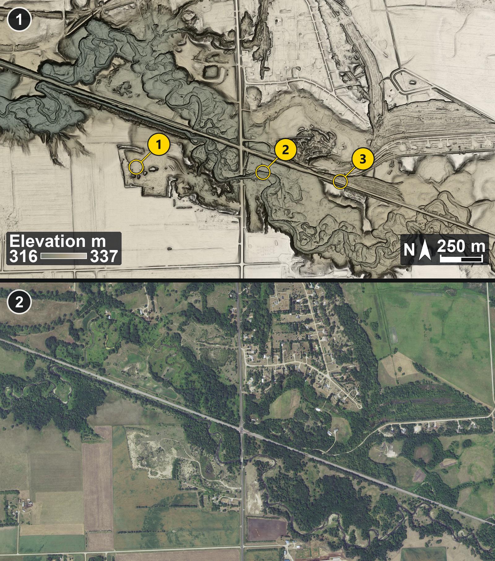
The Herman beach is the highest shoreline of glacial Lake Agassiz. It's a gravel ridge the waves built when the lake stood at its highest level, about 11,700 years ago. Warren Upham described these upper beaches in 1879 and 1881 for the Minnesota Geological Survey, and he's the one who named the lake after Louis Agassiz.
At Muskoda the ridge splits the glacial hills above from the flat old lake floor below. A 1915 USGS guidebook to the Northern Pacific says the railroad dug a large gravel pit into the ridge here for ballast. Muskoda had a post office from 1873, a grain elevator and a potato warehouse. Then in 1909 the railroad moved its line, which left the town about half a mile off the tracks. The post office closed in 1930.
This is my own render of the bare-earth lidar. Just southwest of where the highway crosses the railroad there's a big flat-floored pit with steep squared-off edges, the sandy patch in the air photo. A stream winds across the view in a shallow valley.
1 (top): Bare-earth lidar at Muskoda, Minnesota, on Lake Agassiz's Herman beach
2 (bottom): Air photo of the same area, July 2021
Numbered pins on picture 1 (top):
Pin 1: Floor of the large gravel pit
Pin 2: A winding stream channel
Pin 3: The railroad line
Lidar: USGS 3D Elevation Program (3DEP), public domain.
Imagery: USGS The National Map (NAIP Imagery service), 2021, Public domain.
r/geography • u/LeaveMeAloneAdmins88 • 3d ago
r/geography • u/Ok-Raisin5008 • 2d ago